Global Commercial Satellite Imaging Market Size, Share, Trends, Growth and Forecast 2032

Commercial Satellite Imaging Market By End-User (Government, Defense, Forestry and Agriculture, Energy, Civil Engineering and Archaeology, Commercial Enterprises, Others), By Application (Geospatial Data Acquisition and Mapping, Urban Planning and Development, Disaster Management, Energy and Natural Resource Management, Surveillance and Security, Others), and By Region - Global and Regional Industry Overview, Market Intelligence, Comprehensive Analysis, Historical Data, and Forecasts 2024 - 2032
| Market Size in 2023 | Market Forecast in 2032 | CAGR (in %) | Base Year |
|---|---|---|---|
| USD 3.57 Billion | USD 7.27 Billion | 8.21% | 2023 |
Commercial Satellite Imaging Industry Perspective
What will be the global commercial satellite imaging market size during the forecast period?
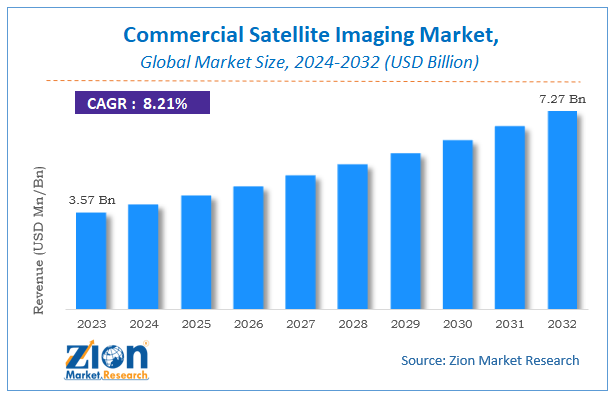
According to a report from Zion Market Research, the global commercial satellite imaging market size was valued at around USD 3.57 billion in 2023 and is projected to reach about USD 7.27 billion by 2032, with a compound annual growth rate (CAGR) of roughly 8.21% between 2024 and 2032.
This report provides a comprehensive analysis of the growth drivers, restraints, and challenges shaping demand across the global commercial satellite imaging market throughout the forecast period, while highlighting high-potential emerging opportunities within the industry.
Key Insights
- As per the analysis shared by our research analyst, the global commercial satellite imaging market is estimated to grow at a CAGR of approximately 8.21% during the forecast period from 2024 to 2032.
- In terms of revenue, the global commercial satellite imaging market size was valued at around USD 3.57 billion in 2023 and is projected to reach USD 7.27 billion by 2032.
- The market is driven by rising adoption of location-based services in defense, intelligence, energy, e-retailing, manufacturing, transportation, and telecommunications, along with technological advancements, broader use of consumer electronics, and tools such as Google Earth.
- Based on the end-user, government and defense applications remain central drivers of demand, supported by border surveillance, security monitoring, and disaster-related needs.
- Based on the application, geospatial data acquisition and mapping represent the core use cases that sustain commercial demand.
- Regionally, North America is expected to witness noticeable growth and hold a leading position, driven by strong adoption of satellite imaging by the U.S. government for military, defense, and disaster management purposes.
Commercial Satellite Imaging Market: Overview
Commercial satellite imaging refers to the acquisition of geospatial data by using satellites to scan the Earth or other planetary surfaces. The images are captured in near real time and support applications such as geographical border surveillance, environmental monitoring, and natural resource assessment. Satellite imaging enables relatively rapid coverage of large areas and the entire globe, which makes it preferable for many use cases compared with alternative imaging methods. Digital collection of imagery also helps reduce data loss and supports economic development and environmental protection objectives.
Commercial Satellite Imaging Market: Dynamics
Growth Drivers
What factors are accelerating the expansion of the commercial satellite imaging market?
Rising adoption of location-based services in defense, intelligence, energy, e-retailing, manufacturing, transportation, and telecommunications is a primary growth driver. Satellite imagery supports timely decision-making across these sectors by providing wide-area, frequently updated geospatial information.
Technological advancements, broader use of consumer electronics, and the availability of accessible platforms that popularize Earth observation data further support market expansion. Digital capture and delivery of imagery reduce certain forms of data loss and improve usability for both government and commercial customers, reinforcing long-term demand.
Restraints
What factors are limiting the growth of the commercial satellite imaging market?
Aerial imaging can capture higher-resolution images than many satellite systems, which may restrain satellite imaging adoption in applications where maximum spatial detail is required. This competitive alternative influences specification choices for certain mapping and inspection tasks.
Cost, licensing, and data-policy considerations can also affect uptake, particularly among smaller commercial users or in regions with limited budgets for geospatial services.
Opportunities
What emerging opportunities exist in the commercial satellite imaging market?
Relatively lower prices for satellite imaging and the launch of improved remote sensing technologies, including higher-resolution cameras and complementary satellite systems, are expected to create numerous growth opportunities. Expanding use in disaster management, urban planning, energy and resource management, and security applications broadens the addressable market.
Growing government adoption in Asia Pacific and continued investment in defense, intelligence, and civilian Earth observation programs worldwide support further commercial opportunities for imagery providers and analytics specialists.
Challenges
What challenges does the commercial satellite imaging market face?
Competition from aerial imaging, the need to continuously improve resolution and revisit rates, and the complexity of integrating satellite data into operational workflows remain important challenges. Ensuring data quality, timely delivery, and compliance with regulatory and security requirements demands ongoing investment in constellation capacity, ground systems, and analytics capabilities.
Commercial Satellite Imaging Market: Report Scope
| Report Attributes | Report Details |
|---|---|
| Report Name | Commercial Satellite Imaging Market |
| Market Size in 2023 | USD 3.57 Billion |
| Market Forecast in 2032 | USD 7.27 Billion |
| Growth Rate | CAGR of 8.21% |
| Number of Pages | 265 |
| Key Companies Covered | DigitalGlobe, Planet Labs, Spaceknow, Harris Corporation, BlackSky Global, Galileo Group, ImageSat International, UrtheCast, European Space Imaging, and SkyLab Analytics |
| Segments Covered | By End-User, By Application, and By Region |
| Regions Covered | North America, Europe, Asia Pacific (APAC), Latin America, Middle East, and Africa (MEA) |
| Base Year | 2023 |
| Historical Year | 2018 - 2022 |
| Forecast Year | 2024 - 2032 |
| Customization Scope | Avail customized purchase options to meet your exact research needs. Request For Customization |
Commercial Satellite Imaging Market: Segmentation
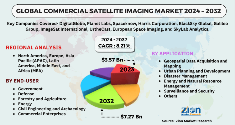
The commercial satellite imaging market is segmented by end-user, application, and region. All the segments of the commercial satellite imaging market have been analyzed based on present and future trends and the market is estimated from 2024 to 2032.
Based on End-User, the commercial satellite imaging market is divided into government, defense, forestry and agriculture, energy, civil engineering and archaeology, commercial enterprises, and others. Government and defense users are central to demand because satellite imagery supports border surveillance, security monitoring, disaster preparedness, and related national-priority missions. Forestry and agriculture, energy, civil engineering, archaeology, and commercial enterprises add diversified demand for mapping, monitoring, and planning applications. This breadth of end users helps stabilize market growth and encourages continuous improvement in image quality, revisit frequency, and analytics services.
Based on Application, the commercial satellite imaging market is divided into geospatial data acquisition and mapping, urban planning and development, disaster management, energy and natural resource management, surveillance and security, and others. Geospatial data acquisition and mapping form a foundational use case that underpins many other applications. Urban planning, disaster management, energy and natural resource management, and surveillance and security drive substantial operational demand by enabling timely monitoring of infrastructure, environmental conditions, critical assets, and security-related activities. Together, these applications expand the commercial value of satellite imagery and support recurring subscription and project-based revenue.
Commercial Satellite Imaging Market: Regional Analysis
Why will North America continue to dominate the global market during the projection period?
North America is expected to witness noticeable growth and maintain a leading position in the commercial satellite imaging market. The region benefits from strong adoption of satellite imaging by the U.S. government for military and defense purposes, including tracking of security-related activities, as well as for disaster management to monitor and help mitigate the impact of major incidents. Established commercial operators, mature procurement frameworks, and sustained investment in Earth observation capabilities reinforce regional leadership. These conditions enable North America to set standards for data quality, delivery, and analytics integration that influence global market development.
Asia Pacific is anticipated to grow considerably, supported by rapid technological advancement, the presence of growing economies, increasing numbers of internet users, and rising adoption of satellite imagery by regional governments. Europe maintains significant demand linked to environmental monitoring, security, and commercial geospatial applications. Latin America and the Middle East and Africa represent emerging opportunities as governments and commercial users expand use of satellite data for resource management, infrastructure planning, and security-related monitoring.
Commercial Satellite Imaging Market: Competitive Analysis
Some of the major players in the global commercial satellite imaging market include;
- DigitalGlobe
- Planet Labs
- Spaceknow
- Harris Corporation
- BlackSky Global
- Galileo Group
- ImageSat International
- UrtheCast
- European Space Imaging
- SkyLab Analytics
Segments Covered
This report segments the global commercial satellite imaging market into:
By End-User
- Government
- Defense
- Forestry and Agriculture
- Energy
- Civil Engineering and Archaeology
- Commercial Enterprises
- Others
By Application
- Geospatial Data Acquisition and Mapping
- Urban Planning and Development
- Disaster Management
- Energy and Natural Resource Management
- Surveillance and Security
- Others
By Region
- North America
- The U.S.
- Canada
- Mexico
- Europe
- France
- The UK
- Spain
- Germany
- Italy
- Rest of Europe
- Asia Pacific
- China
- Japan
- India
- Australia
- South Korea
- Rest of Asia Pacific
- The Middle East & Africa
- Saudi Arabia
- UAE
- Egypt
- Kuwait
- South Africa
- Rest of the Middle East & Africa
- Latin America
- Brazil
- Argentina
- Rest of Latin America
Table Of Content
Methodology
FrequentlyAsked Questions
Commercial satellite imaging is the process of obtaining geospatial data by using satellites to scan the Earth or other planets. The resulting images support applications such as border surveillance, environmental monitoring, natural resource assessment, urban planning, and disaster management.
The global commercial satellite imaging market is driven by rising adoption of location-based services across defense, intelligence, energy, and other sectors, technological advancements, broader use of consumer electronics, and increasing availability of accessible Earth observation platforms.
The global commercial satellite imaging market size was valued at approximately USD 3.57 billion in 2023 and is expected to reach around USD 7.27 billion by 2032.
The global commercial satellite imaging market is expected to grow at a compound annual growth rate (CAGR) of approximately 8.21% during the forecast period from 2024 to 2032.
North America is expected to contribute notably and hold a leading position, supported by strong U.S. government adoption for military, defense, and disaster management applications.
Some of the major players leveraging the commercial satellite imaging market growth are DigitalGlobe, Planet Labs, Spaceknow, Harris Corporation, BlackSky Global, Galileo Group, ImageSat International, UrtheCast, European Space Imaging, and SkyLab Analytics.

HappyClients